Print Version
Generation
Generation
Making Waves
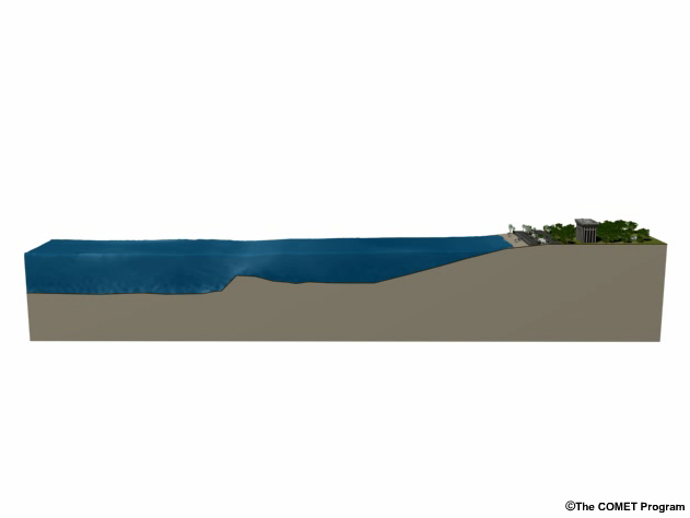
For a tsunami to form, water must be displaced. Waves form when a large object enters the water or the seafloor rapidly shifts, displacing water.
Large Object Enters Water
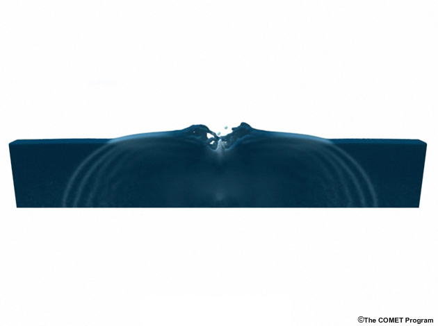
Click image to view animation.
Seafloor Shifts Up
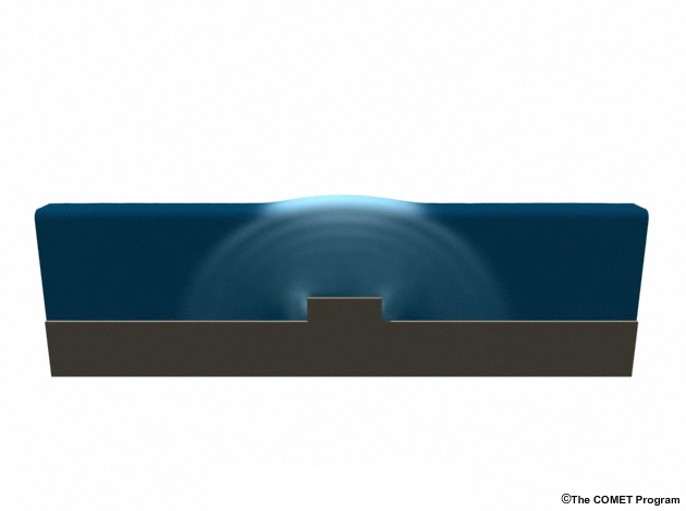
Click image to view animation.
Seafloor Shifts Down
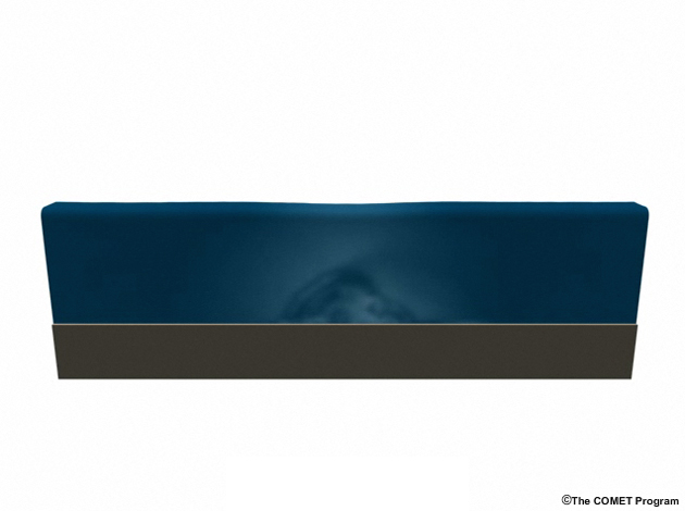
Click image to view animation.
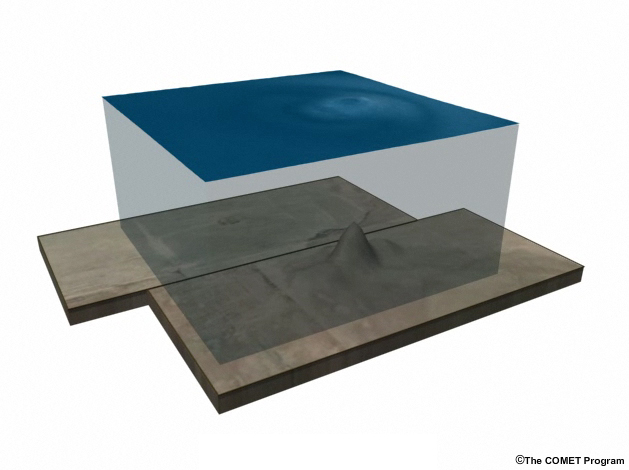
Seafloor Shifts Sideways
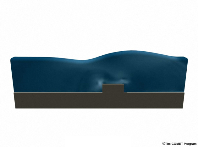
Click image to view animation.
Click the tabs to view other forms of displacement.
Tsunami Triggers
Earthquakes
Click image to view animation.
Undersea earthquakes are the most common cause of tsunamis. Tsunamigenic earthquakes uplift or downdrop rock and sediment above a fault, resulting in a vertical displacement of the seafloor that can extend for hundreds of kilometers along the length of the rupture. The water above the rising or falling seafloor travels up or down with it, a disturbance that creates radiating waves.
Earthquakes are the most common cause of tsunamis. Yet while there are thousands of undersea earthquakes every year, only a few generate tsunamis.
Subaerial Landslides
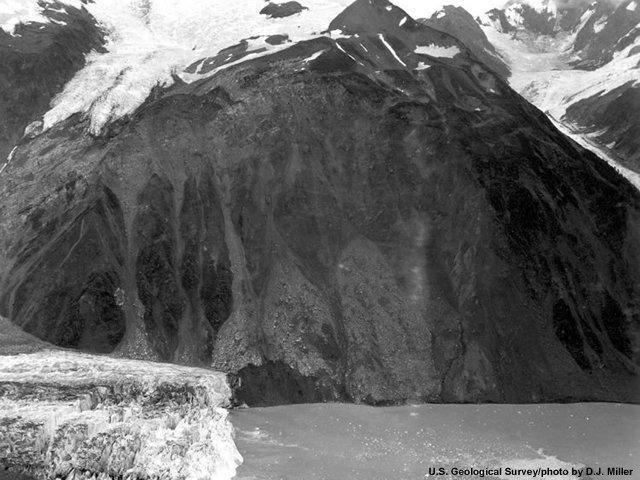
While not as common a tsunami source as undersea earthquakes, subaerial, or land-based, landslides and glacial calving into the sea can trigger tsunamis of incredible height. In some cases, heavy rains saturate soils, causing overly steep slopes to fail and fall into the ocean. In other cases, earthquakes trigger slides.
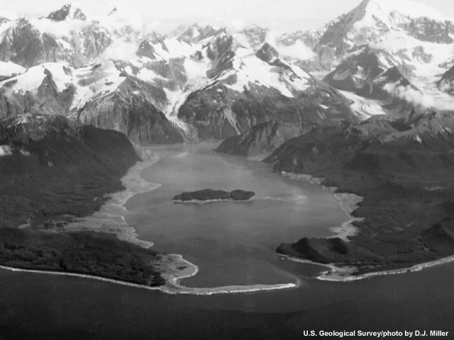
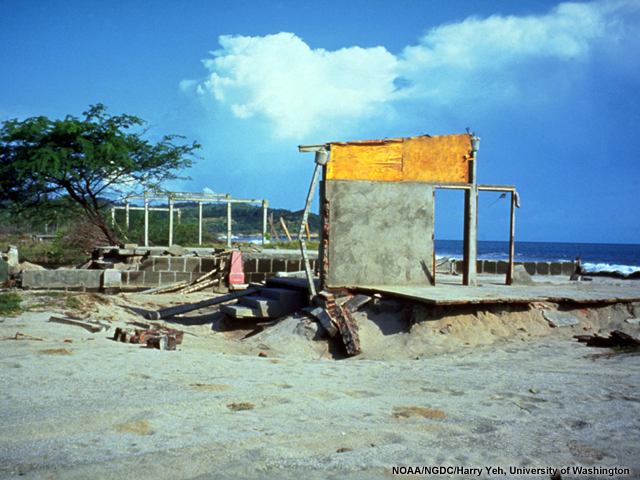
An earthquake-induced rock slide into Lituya Bay, Alaska, in 1958 triggered a tsunami that climbed 525 m (1,720 ft) up the hill opposite the slide. The wave swept away trees 30 to 50 m (100-160 ft) above the water down the length of the bay. This gave the bay a bathtub ring, or trimline, which is visible to this day, 50 years later.
Submarine Landslides
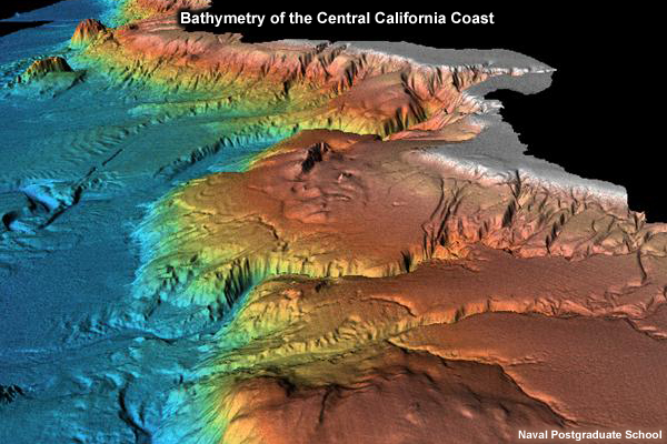
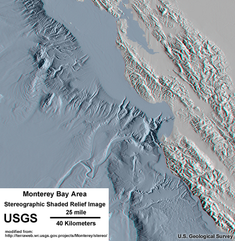
Beneath the ocean lie canyons and cliffs that rival the Grand Canyon, as in this image of Monterey Bay, where the bottom of the canyons lies some 4 km (2.5 mi) beneath the surface.
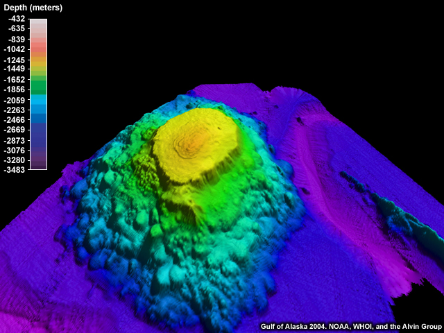
In addition to the sloped boundaries of subduction zones and ocean trenches, the edges of continental shelves, seamounts, atolls, submarine mesas called guyots, and volcanoes also have slopes capable of failure.
Over time, sediment and other material has also settled on the edges of continental shelves, producing thick wedges of weak, unconsolidated sediment perched on the edges.
Earthquakes are the most common trigger of landslides, but overly steep slopes can suddenly fail on their own. Seawater rushes in to fill the void left behind, generating waves.
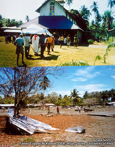
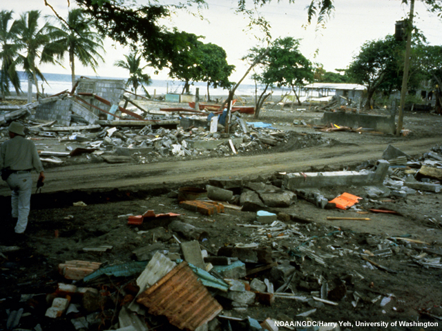
On July 17, 1998, a magnitude 7.1 earthquake ruptured the junction of the Australia and Pacific plates near Sissano Lagoon, Papua New Guinea, triggering an undersea landslide and accompanying tsunami that reached 15 m (49 ft) above sea level. Twenty-two hundred died.
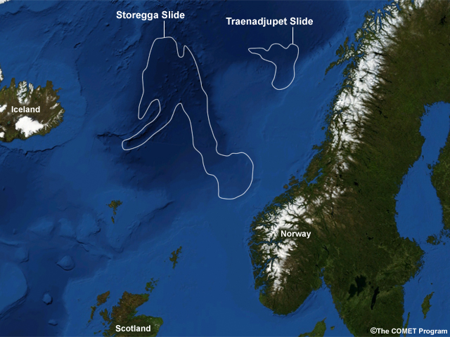
Scientists have measured massive submarine landslide fields such as the Agulhas submarine slide field off South Africa (20,000 km3, or 4,800 mi3 in size) or the Storegga submarine slide near Norway (3,500 km3, or 840 mi3, in size), the largest of which triggered tsunamis that left deposits as much as 50 m (160 ft) above sea level.
Volcanoes
Volcanoes, too, can trigger tsunamis.
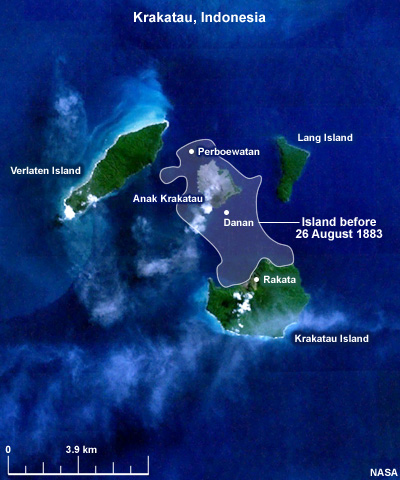
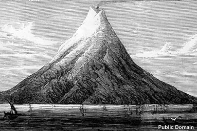
On August 27, 1883, the volcano Krakatau in the Sunda Strait of Indonesia collapsed into the ocean after a series of explosions, generating multiple tsunamis and killing over 30,000 people, making it one of the world’s deadliest tsunamis.
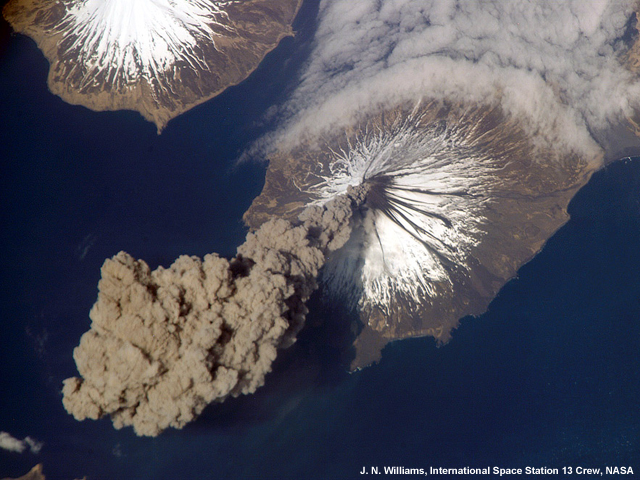
Eruptions can generate tsunamis in several ways two of which are landslides off the flanks (also known as debris avalanches) and pyroclastic flows—that is, huge avalanches of hot gas and ash—entering the ocean and displacing water. Eruptions can also produce shockwaves in the atmosphere that will induce a small tsunami. Not any volcano will do; a volcano must be close to shore or not far beneath the sea surface to produce a significant tsunami.
Meteorites
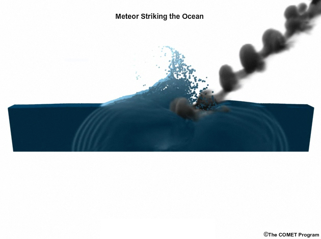
Click image to view animation.
Meteorites are another significant, though rare, source of tsunamis. Evidence indicates massive impacts have occurred more than once on Earth—with life-altering effects.
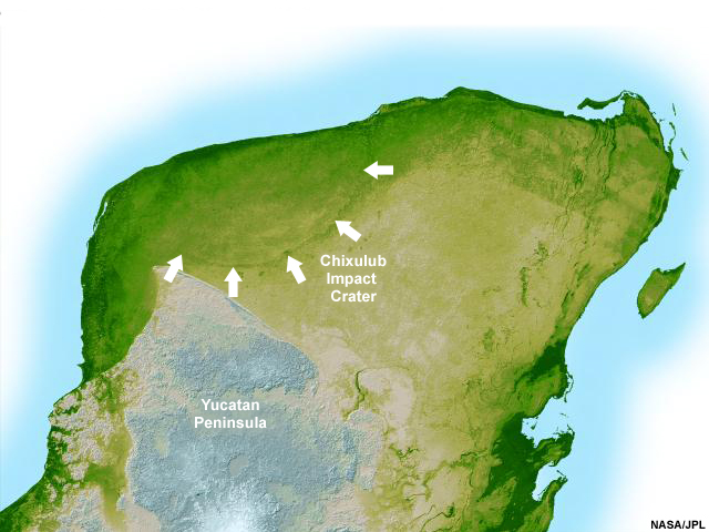
The most famous such event is the Chixulub impact, which likely caused a mass extinction at the end of the Cretaceous period 65 million years ago about the time most dinosaurs disappeared. Among other calamities, the impact generated a wave that reached hundreds of miles inland around the nascent Gulf of Mexico.
Summary Questions
Question 1
How do earthquakes cause tsunamis? (Choose all that apply.)
The answers are B and C. Earthquakes cause tsunamis by moving water up or dropping it down relative to sea level. The water reacts by making waves. Submarine or subaerial landslides can also displace a lot of water, and have caused significant tsunamis.
Question 2
Which of the following are ways that volcanoes produce tsunamis? (Choose all that apply.)
The correct answers are B, C, and D. Lava flows into the sea displace seawater too slowly to form tsunamis.
Question 3
Submarine landslides can occur without earthquakes. (Choose the best answer.)
True. Sometimes slopes suddenly fail without any obvious cause.
How Earthquakes Generate Tsunamis
Plate Tectonics
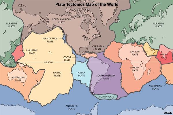
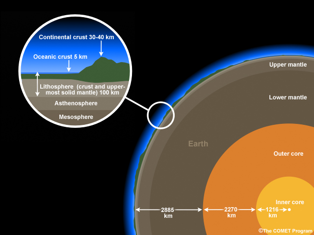
Earth is encased in a thin shell of brittle rock called the lithosphere. But the lithosphere isn’t one piece. It’s broken into fragments called plates that sit on a ductile rock layer called the asthenosphere. The plates are many different sizes, ranging from the Pacific or Eurasian plates down to the Juan de Fuca plate. The earth’s crust, which composes the upper section of the lithosphere, is of two basic types: thick, buoyant continental crust and thinner, denser ocean crust. Most plates contain both continental and oceanic crust, but a few, like the Pacific, contain just oceanic.
Plate Boundaries and Faults
Earth’s plates sit atop the thick, ductile asthenosphere. This rock is deformable, like taffy or silly putty, and allows the overlying plates to move independently. The plates are constantly jostling each other, driven by convection currents in the mantle. Plate boundaries are of three types: convergent, divergent, and transform, and each can cause tsunamis, though convergent boundaries are most often responsible.
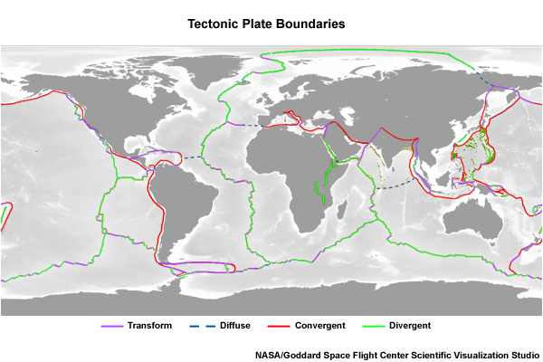
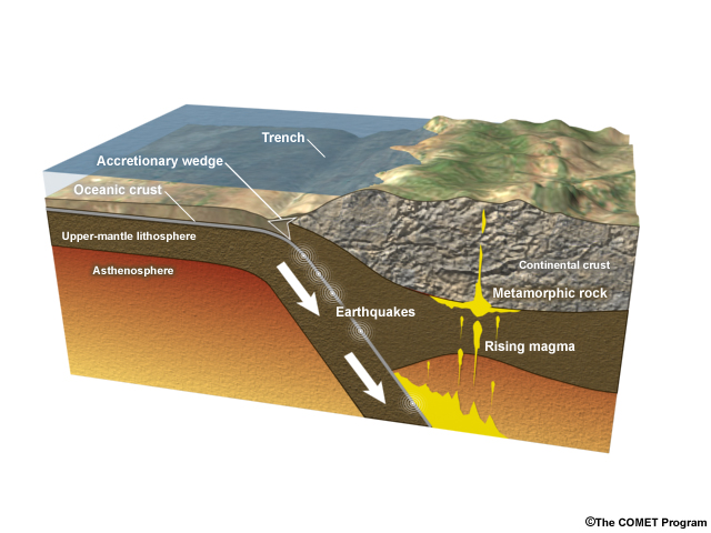
When oceanic and continental plates move toward each other at a convergent boundary, one dives beneath the other. Typically, the denser oceanic plate sinks under the lighter continental plate or another oceanic plate at places called subduction zones. In places where two continental plates meet, neither may dive beneath the other and great mountain ranges like the Himalayas may form.
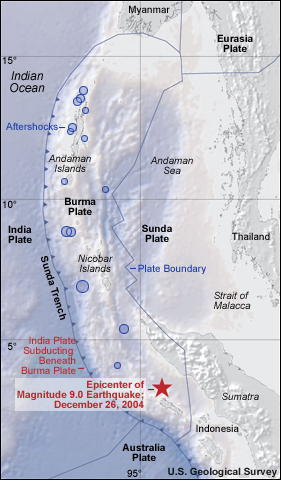
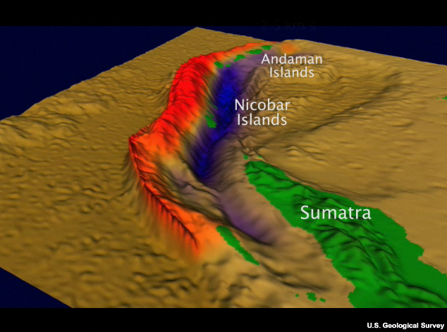
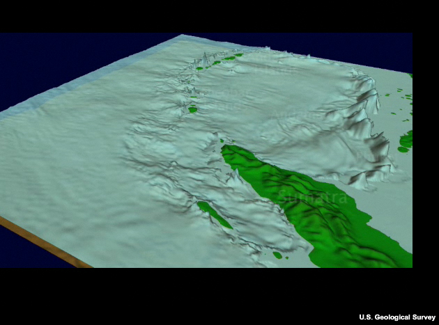
The world’s largest earthquakes, like the earthquake which generated the Indian Ocean tsunami of 2004, tend to occur at convergent plate boundaries. Faults—or surfaces where rocks grind past each other—in subduction zones are generally called reverse faults. These faults occur in compressive environments.
Plates can also separate at divergent boundaries, where they move away from each other and rising magma creates new seafloor between. Earthquakes here, at oceanic ridges, are numerous but tend to be smaller than the largest observed in convergent boundaries. Most faults in these regions are called normal faults. Normal faults are found wherever the crust is under tension, oceanic ridges being the most common location.
Finally, plates can also meet at transform boundaries, where they grind past each other. These faults are called strike-slip faults. These boundaries can also produce significant quakes, though not often significant tsunamis. The San Andreas Fault in California is of this type, and is famous as the source of the 1906 San Francisco earthquake.
Let’s look at how tsunamis relate to tectonic plate boundaries.
Click image to view animation.
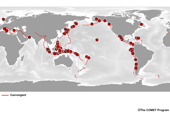
Here is a map of the planet’s subduction zones in red, and here are the sources of major historical tsunamis. It’s easy to see that plate motion along subduction zones triggers most earthquake-induced tsunamis.
Earthquake Epicenters
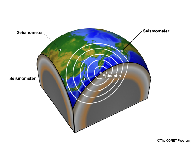
Timely tsunami warnings depend on identifying earthquake epicenters and other characteristics as soon as possible. Using the seismic waves generated by earthquakes, scientists can locate earthquakes anywhere in the world once the seismic energy has reached enough seismometers.
Click image to view animation.
When locating an earthquake, scientists determine four parameters: origin time, latitude, longitude, and depth. Earthquakes normally occur shallower than 50km (30 miles), though in subduction zones the depth can reach 700 km (420 miles). The point at which the rupture begins is known as the hypocenter, or focus, and requires knowledge of all four parameters. The point on the surface directly above the hypocenter is known as the epicenter. Since earthquakes which generate tsunamis can extend for hundreds of kilometers, it's important to remember that the epicenter refers to the rupture initiation location and not the entire fault zone.
Earthquake Magnitude

Once an earthquake’s location is computed, scientists can determine its magnitude. Earthquake magnitude is an indirect measure of the energy released by an earthquake. Many techniques have been developed to determine earthquake magnitude since Charles Richter devised the first scale in 1935. Most techniques base magnitude on the amplitude and frequency of ground shaking and match the result to the original Richter scale at magnitudes where it is valid. Modern techniques extend the magnitude scale accuracy range to higher magnitudes and provide better correlation with tsunami generation.
One of the most difficult aspects of providing tsunami warnings quickly determining the magnitude. The rupture time in a large, tsunami-generating earthquake may exceed five minutes. If warnings are to be issued within five minutes, the computed magnitude will likely underestimate the real magnitude as the quake will not yet be complete. As more data are acquired, magnitude estimates will change, with the final values usually not available for several days.
Earthquake Magnitudes that Produce Tsunamis
What do you think is the usual minimum earthquake magnitude that produces damaging tsunamis that can cross oceans? (Choose the best answer.)
The correct answer is C.
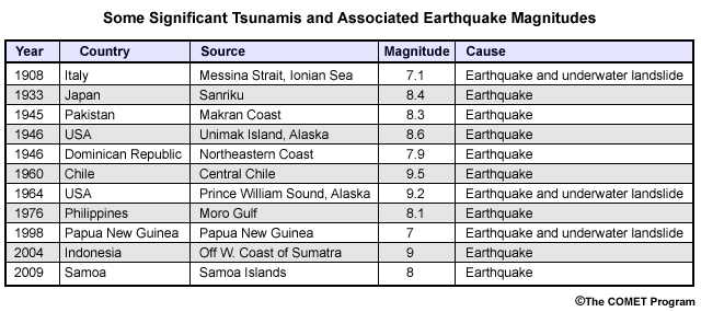
Not just any earthquake will trigger a major tsunami. Generally, earthquakes must exceed magnitude 8.0 to generate a tsunami dangerous at distant locations. However, earthquakes with magnitudes of 7 or larger can sometimes trigger significant tsunamis locally.
Tsunami Earthquakes
Stronger earthquakes, in general, produce bigger tsunamis, but this isn’t always the case. Sometimes earthquakes produce unusually large tsunamis relative to their magnitudes. In the 1970’s the term “Tsunami Earthquake” was coined to designate earthquakes which generate a larger tsunami than their magnitude would indicate.
How can this happen? The sediments that accumulate in trenches are unconsolidated and water-saturated. If these sediments are subducted with the descending plate, some of this water can become trapped in the sediments. This trapped water decreases the strength of the rocks in the fault zone. When an earthquake occurs, it easily propagates through these weak rocks to the surface. Such an earthquake could have a large displacement over a large area, but produce a lower magnitude due to the weak rocks it ruptures and fail to generate strong shaking.
Another way tsunami earthquakes can produce a large tsunami relative to its magnitude is by rupturing with a slower than normal velocity. Due to the slow rupture, magnitude scales underestimate the true size of the earthquake. Quakes like this are also known as slow earthquakes.
Tsunami earthquakes can be very dangerous as they are often are accompanied by gentle or imperceptible shaking, generate local tsunamis with little time for warning, and are difficult for scientists to identify quickly.
On September 2, 1992, a slow-moving rupture produced an earthquake in a shallow-dipping subduction zone between the Cocos and Caribbean plates. The rupture propagated along the fault at just 1-1.5 km/s, relatively slow by earthquake standards since most move along the fault at about 2.5 km/s. The earthquake was barely felt by people on the coast. The ocean responded, though.
At the point on shore closest to the earthquake epicenter the resulting tsunami rose 10.7 m (35 ft) high. Healthy adults were able to flee when they saw the waves, but 170 mostly sleeping children or infirm adults died. The moment magnitude was 7.7, but the tsunami was about 10 times higher than expected for an earthquake of that magnitude.
Depth
How do you think depth of an earthquake affects tsunamis? (Choose the best answer.)
The correct answer is B. Shallow earthquakes tend to produce bigger tsunami.
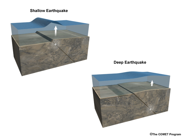
The deeper the earthquake, the less it will perturb the seafloor. While deep earthquakes can be large, quakes 100 km or more below the surface rarely generate tsunamis.
Tsunami Development
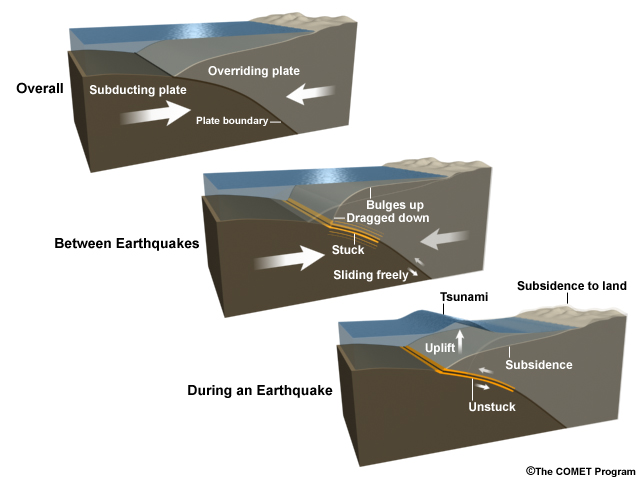
As a plate descends at a subduction zone, it gets stuck and the overriding crust slowly bulges up over hundreds of years as the strain builds. During an earthquake, the leading edge of the overriding plate breaks free and springs up. Behind the leading edge, the plate stretches and the surface falls. This is called subsidence. Subsidence can occur in the ocean as well as hundreds of miles inland depending on the width of the rupture area. The vertical rise and drop of the sea floor triggered by this slippage generates a tsunami.
Click image to view animation.
When earthquakes occur, slippage across the fault doesn’t happen simultaneously everywhere along the rupture. It starts at the earthquake’s focus and unzips along the fault. It may take several minutes for the rock to finish slipping.
How fast do tsunamis develop? In the Indian Ocean tsunami, 1,100 km (680 mi) of the fault ruptured. The break raced north at about 2.5 km/second (that’s 10,000 km/hr, or 6,200 mi/hr!), taking 8 minutes to reach the northern end of the rupture. The ocean floor usually moves upward at 10 cm to 1 m per second (.5 - 3.5 km/hr, or 0.3-2.2 mi/hr). That is a relatively slow motion compared to the rupture speed, taking seconds to finish. Once the rock begins to move, the ocean goes for a ride along with the plates.
Click image to view animation.
That sets the tsunami in motion, which travels at around 220 meters per second (which is 800 km/hr or 500 mi/hr) in deep water. For comparison, the rupture itself is moving along the fault 10-12 times faster. Yet in the case of the Indian Ocean tsunami, because the rupture traveled 1,100 km (680 mi) north of the quake’s origin before it stopped, tsunami waves started radiating from the Indian Ocean Earthquake before the northern end of the rupture had even started moving.
Tsunamis from Strike-Slip Faults
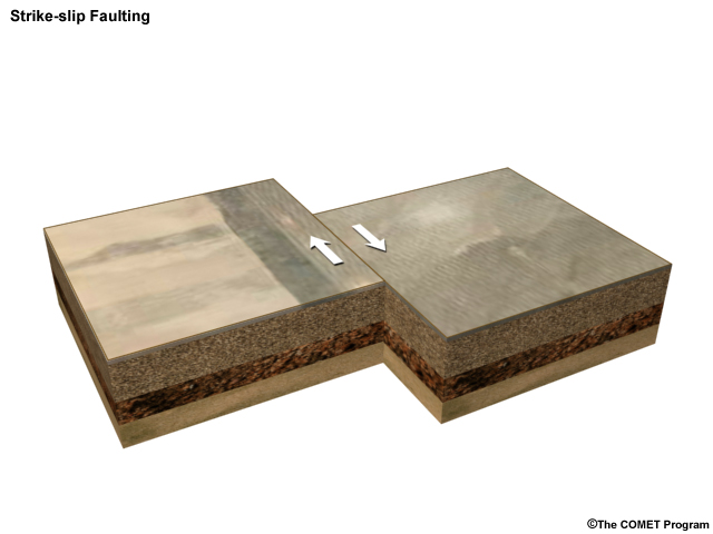
Though subduction zones generate the majority of tsunamis, strike-slip faults, where the rocks on either side of a fault grind past each other with little or no vertical motion, are also capable of generating tsunamis. About 10-15% of damaging tsunamis are triggered along strike-slip faults. Such a tsunami was generated by a magnitude 7.1 strike-slip earthquake near Mindoro Island in the Philippines on Nov. 15, 1994, producing up to 6 meters of runup onshore and killing 41.
How is this possible? As with other earthquakes, strike-slip earthquakes can trigger landslides or slumping that cause tsunamis.
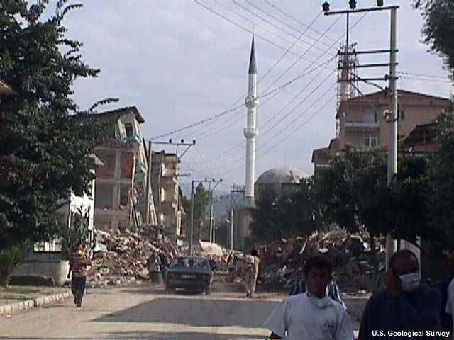
A magnitude 7.4 strike-slip earthquake on Aug. 17, 1999 near the Sea of Marmara in northwest Turkey likely generated a 2.5 m tsunami through submarine slumping. And the 1958 earthquake that produced the Lituya Bay landslide and tsunami occurred on a strike-slip fault.
Click image to view animation.
Strike-slip faults can also produce tsunamis if sloped seafloor or seamounts are near the slippage. The sudden movement of the mount can act like a paddle that pushes the water horizontally, like suddenly pushing a block across the bottom of a bathtub. This will likely produce only a local tsunami, however.
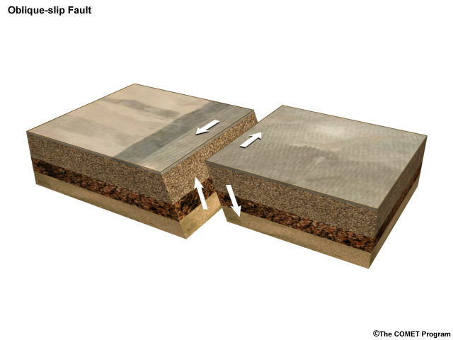
Few faults have purely thrust or purely strike-slip motion. Most earthquakes on strike-slip faults have some vertical component—a feature called obliquity.
Summary Questions
Question 1
Which of the following are terms for tectonic plate boundaries? (Choose all that apply.)
The correct answer is A, C, and D. Plates come together at convergent boundaries, move apart at divergent, and move past each other at transform boundaries.
Question 2
(Use the selection box to choose the answer that best completes the statement.)
Oceanic plates are denser and thinner than continental plate sections, which explains why it is the plate type that is subducted at convergent zones.
Question 3
Which type of plate boundary tends to produce the most tsunamis? (Choose the best answer.)
The correct answer is A. Convergent boundaries, where ocean plates are subducted at trenches, produce the most tsunamis because they produce the largest earthquakes.
Question 4
What is a tsunami earthquake? (Choose the best answer.)
The correct answer is D.
Question 5
Why are only 10-15% of damaging tsunamis produced by strike-slip faults? (Choose the best answer.)
The correct answer is C.
Question 6
What are some ways strike-slip faults can cause tsunamis? (Choose all that apply.)
A, B, and D are correct.
Summary Exercise
Question 1
Based on what you can see, which of the following could be causes of tsunamis in this image? (Choose all that apply.)
Click on red boxes to zoom-in. There may be more or fewer correct answers than there are zoom-ins.
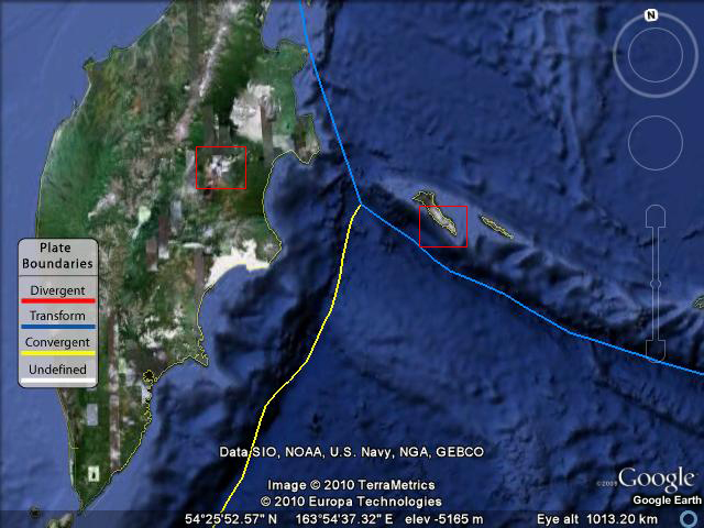
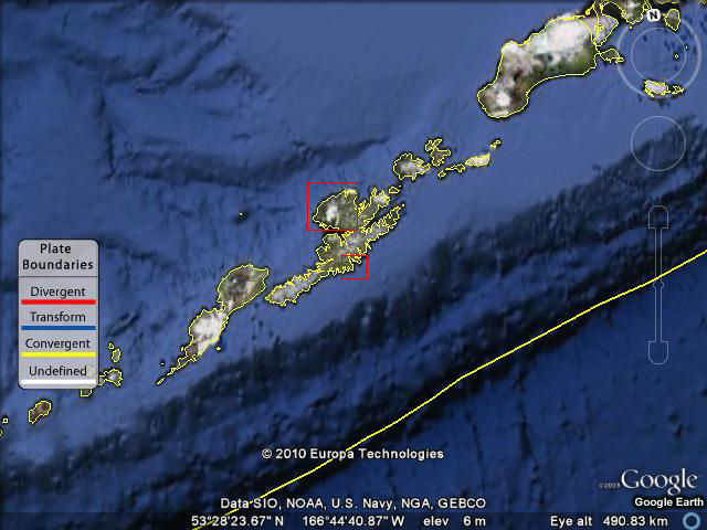
The correct answers are A, C, D and E. This is a view of the Kamchatka Peninsula in eastern Russia. A subduction zone runs next to the peninsula, potentially contributing to subduction zone earthquakes, submarine landslides, and volcanic eruptions that could case tsunamis. A strike-slip fault (transform boundary) lies next to some seamounts and other large underwater features nearby.
Question 2
Based on what you can see, which of the following could be causes of tsunamis in this image? (Choose all that apply.)
Click on red boxes to zoom-in. There may be more or fewer correct answers than there are zoom-ins.
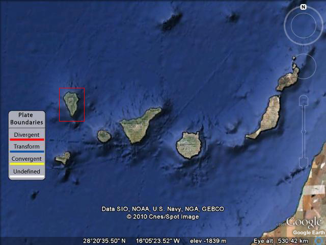
The correct answers are B, C, and D. These are the Spanish-controlled Canary Islands off the Northwest coast of Africa. The second image is of the volcanic island of La Palma near the ocean, which in addition to being active, has very steep sides that some worry could cause a subaerial landslide.
Question 3
Based on what you can see, which of the following could be causes of tsunamis in this image? (Choose all that apply.)
Click on red boxes to zoom-in. There may be more or fewer correct answers than there are zoom-ins.
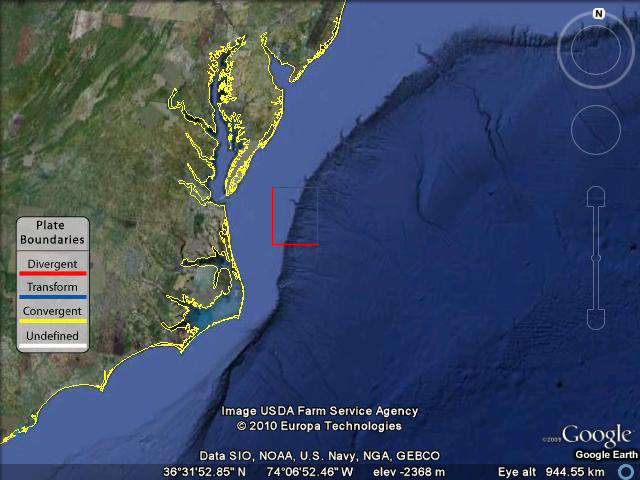
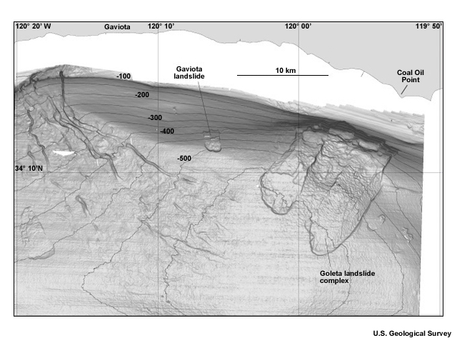
The correct answer is C. This is a part of the east coast of the United States. Submarine landslides frequently begin on submarine slopes like the edges of continental shelves.
Question 4
Based on what you can see, which of the following could be causes of tsunamis in this image? (Choose all that apply.)
Click on red boxes to zoom-in. There may be more or fewer correct answers than there are zoom-ins.
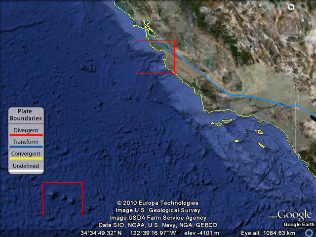
The correct answers are C and E. This image shows southern California and Monterey Bay. A strike-slip fault, the San Andreas, runs through the area and many seamounts are nearby. There are also canyons in Monterey Bay that could produce submarine landslides.
Question 5
Based on what you can see, which of the following could be causes of tsunamis in this image? (Choose all that apply.)
Click on red boxes to zoom-in. There may be more or fewer correct answers than there are zoom-ins.
The correct answers are A, B, C, and D. These are the Aleutian Islands in southwest Alaska. A subduction zone with a steep dropoff lies nearby, and volcanoes dot the islands. Steep-sided inlets are found on the south side. As a result, subduction zone earthquakes, submarine landslides, volcanoes, and subaerial landslides are possible tsunami causes in this area.