
Table of Contents
Volcanoes - Understanding the Source
The Earth is geologically active, with an average of about ten volcanoes erupting daily. Most of these events are small eruptions, but sometimes a small eruption is a precursor to a larger event. While there have been many cataclysmic eruptions in historic times, not every eruption is explosive or produces volcanic ash. Knowing what to expect from each type of eruption will help you evaluate the situation and provide better service to your customer.
Specifically, this module will help you:
- Identify the geological elements involved in volcanic eruptions
- Locate currently active volcanoes and major fault lines and plate boundaries in the world
- Describe the process of an explosive volcanic eruption
- Identify eruption types and describe their ash dispersion patterns
- List the most common volcanic hazards and the threats they pose
Eruption Dynamics
Earth’s outermost solid layer is called the lithosphere. It includes the crust and the upper part of the mantle. The lithosphere is broken into a series of tectonic plates that glide on the fluid-like asthenosphere: a slow-moving layer of semi-solid rock.
Question
Where do you think geological activity like earthquakes and volcanic eruptions occur most frequently? (Choose the best answer.)
The correct answer is d).
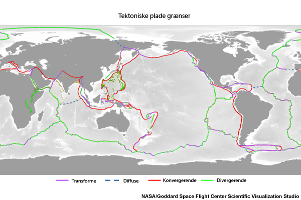
The locations where plates interact are known as plate boundaries and are areas of geological activities like earthquakes and volcanic eruptions.
In general, there are three types of boundaries defined by the relative motion of the plates:
- Convergent boundaries — where crust is destroyed as one plate dives under another, such as the Andes Mountains or the Marianas Trench.
- Divergent boundaries — where new crust is generated as the plates pull away from each other, such as the Mid-Atlantic Ridge.
- Transform boundaries — where crust is neither produced nor consumed as the plates slide horizontally past each other, such as the San Andreas fault.
Note that while volcanism is abundant along divergent and convergent plate boundaries, it is far less common along transform plate boundaries. To learn more about plate tectonics, visit http://volcanoes.usgs.gov/about/edu/dynamicplanet/nutshell.php.
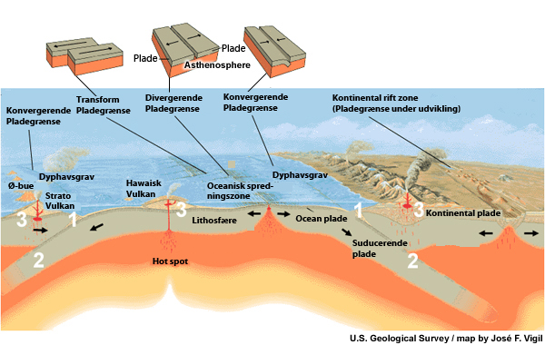
Most explosive volcanic eruptions occur along convergent boundaries where one plate sinks (is subducted) under another (1) as can be seen on this image. As the oceanic crust descends under continental crust, it encounters progressively greater pressure. At a depth of about 62 miles (100 km) (2), oceanic crust releases fluids, which rise and initiate partial melting of the overlying continental crust. The molten rock, called magma, rises toward the surface and collects in magma chambers (3). The rupture in the Earth’s crust through which magma, volcanic gases and hydrothermal fluid reach the surface is called a volcano. (US Geological Survey)
Volcanic Regions
Most of the explosive volcanism in the world occurs along the circum-Pacific “Ring of Fire.” As seen in the image below, the Ring of Fire is defined by a nearly continuous series of oceanic trenches, island arcs, and volcanic mountain ranges and/or boundaries of several plates. It encircles the periphery of the Pacific Ocean Basin.
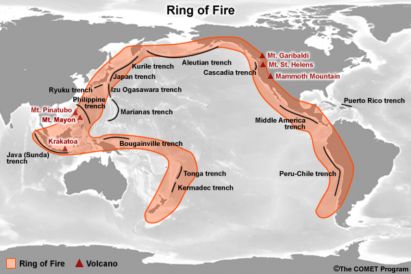
The Philippines, Indonesia, the islands of Japan, the Alaskan and Cascade Range volcanoes are all part of the circum-Pacific Ring of Fire.
See http://pubs.usgs.gov/gip/63/ for more information on Cascade Range volcanoes.
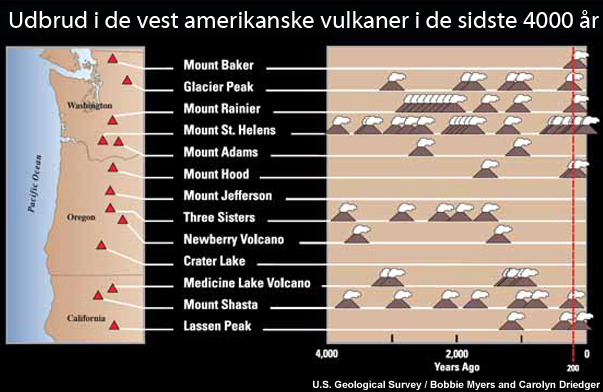
Volcanoes have been erupting in the Cascade Range for over 500,000 years. During the past 4,000 years, eruptions have occurred at an average rate of about 2 per century. This chart shows 13 volcanoes on a map of Washington, Oregon, and northern California, and time lines for each showing the ages of their eruptions.
Yet, along the northern periphery of the Ring of Fire, essentially from Kamchatka Peninsula to southeast Alaska, there were 97 eruptions between 1970 and 2008. These eruptions ejected volcanic ash to more than 20000 ft (>6 km). In some instances, the activity lasted several weeks or even months and required a separate hazard response. Thus, there were “approximately 300 explosive eruptions that resulted in plumes at altitudes greater than 6 km over those 38 years.” (Dean, Dehn, 2011)
Not all volcanoes occur along the Ring of Fire, or even along subduction zones. There are several other areas in the world with active volcanoes, like Iceland and Italy. In all instances, however, prevailing winds can carry the ash from an explosive eruption through both adjacent and distant routes thereby disturbing air traffic and other human activities.
Question
Of the three types plate boundaries, which produces the most explosive volcanism? (Choose the best answer.)
The correct answer is a).
Convergent boundaries are prone to explosive volcanic eruptions because they allow magma to percolate upward and form pockets that can serve as magma sources for volcanoes. Divergent plate boundaries are also volcanically active but most eruptions occur along the ocean floor and their impact is minimal. Next, we will learn more about different eruption types.
Eruption Types
Volcanoes come in different shapes and sizes, however, there are several common features.
- Each volcano has a shallow "plumbing system” that may include a magma chamber or a zone where magma can accumulate.
- The magma chamber is connected to the surface by a conduit system, simplified in the graphic below as a vertical pipe.
- The motion associated with volcanic activity can also create fractures connected to the central vent or the magma chamber. Such fractures can result in flank eruptions of magma, gases and ash.
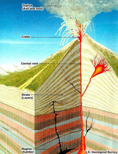
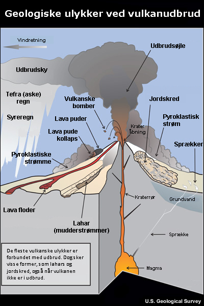
A cross-section view of a typical volcano during an eruption. Starting at the bottom, magma rises through strata (rock layers) to the surface, following one or more conduits. While most magma rises to the top of the volcano and erupts through the central vent, other magma may follow diverging conduits and erupt on the flanks of the volcano. Some magma may never reach the surface, intruding laterally into the strata instead. The magma rises through more than one crack; some of the magma pushes up the strata layers while other magma moves to the top opening(s) of the volcano. The raised opening that emits magma is called the cone. The crack that reaches to the top of the cone is called the Central Vent. Along with the magma, the volcano emits a cloud of tephra (ash and large particles). (US Geological Survey)
The production of ash during a volcanic eruption is controlled by the characteristics of the erupting magma, including chemical composition, crystal content, temperature, dissolved gases, and also by interaction with water, especially groundwater.
Question
Can a volcano erupt without producing volcanic ash? (Choose the best answer.)
The correct answer is a) Yes.
In some cases, the amount of dissolved gasses and characteristics of the magma are such that no ash is produced. In these instances, magma with very low volatile content (dissolved water and gases) tends to erupt more quietly, producing little or no volcanic ash. The amount of volatile content contributes to the eruption style of volcanoes.
Depending on these characteristics and the rate of magma eruption, volcanoes display a marked range of eruption styles. For example, volcanic eruptions range from:
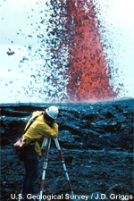
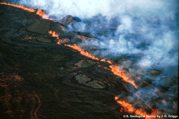
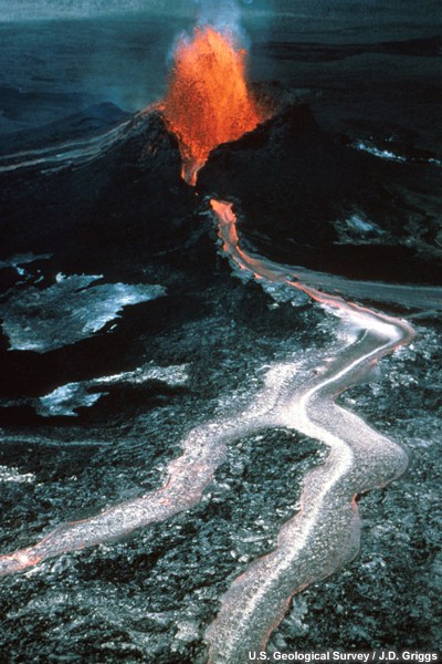
- Effusion of lava fountains and flows with very little ash erupted (such as Kilauea in Hawaii). Some of these non-explosive eruptions are extruded from fissures, can cover vast areas, and are the least dangerous type.
 Click to play video
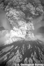
- Extremely explosive eruptions that inject large quantities of ash and gases high into the stratosphere (such as Mount Pinatubo). These explosive eruptions result from rapidly expanding gases within the rising magma. They cause widespread ash fall, pyroclastic flows, debris avalanches, landslides, and lahars.
 Click to play video
Explosive eruptions are dependent upon the amount of dissolved gases in the magma and its viscosity:
- A low-viscosity magma (like Hawaiian eruptions) allows gases to readily escape to the surface, therefore reducing the probability of explosive release.
- Conversely, a high-viscosity magma (like that from Mount St. Helens) will retain the gases and increase the pressure. This increases the potential of explosive release.
Classification of Volcanic Eruptions
How high does ash need to rise before impacting aviation?
It depends. Long travelling aviation is impacted by eruptions that project ash to 25,000 ft (7.6 km) and above. If the eruption is near an airport, the impact starts at the surface.
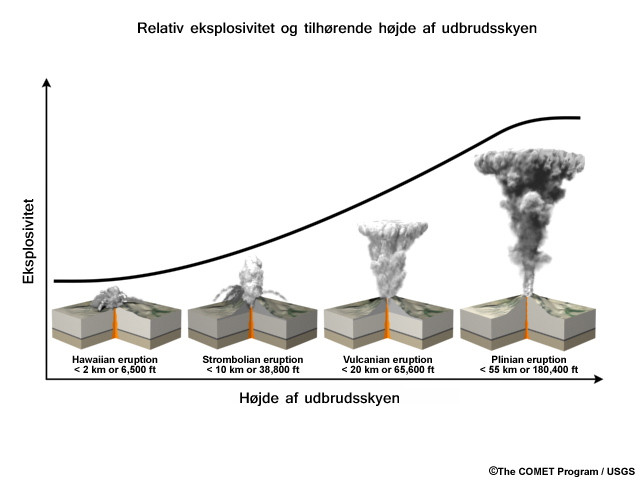
Volcanic eruptions form a continuum from small quiet affairs to large explosive catastrophes. Volcanologists have developed many schemes to categorize eruptions. Since the focus of this module will be on the more explosive types that, potentially, impact aviation, climate, maritime, and society through the expulsion of volcanic ash and gases, the meteorologist should be familiar with these four eruption types:
- Hawaiian
- Strombolian
- Vulcanian
- Plinian
Note: A volcano commonly displays a distinctive pattern of behavior and its eruption is often labeled with the name of a more well-known volcano that displayed similar characteristics. Furthermore, while some volcanoes may exhibit only one characteristic type of eruption during an interval of activity; others may display the entire range of types.
Classification of Volcanic Eruptions » Hawaiian Eruptions
"Hawaiian" eruptions may occur along fissures or fractures that serve as linear vents. In fissure-type eruptions, molten, incandescent lava spurts from a fissure on the volcano’s flank and feeds lava streams that flow downslope. Such eruptions rarely produce volcanic ash.
 In central-vent eruptions, a fountain of fiery lava spurts to a height of several hundred feet or more building a cone of spatter around the vent.
Classification of Volcanic Eruptions » Strombolian Eruptions
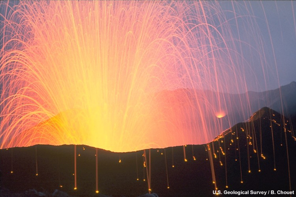
In a Strombolian-type eruption, huge clots of molten lava burst from the summit crater to form luminous arcs through the sky. The lava fragments consist of partially molten volcanic bombs (see http://volcanoes.usgs.gov/images/pglossary/bomb.php for more information) that fly through the air. Lava clots collect on the flanks of the cone, and combine to stream down the slopes in fiery rivulets. Particularly violent Strombolian explosions can produce ash clouds but they are normally short-lived and do not rise high into the atmosphere.
Classification of Volcanic Eruptions » Vulcanian Eruptions
In a Vulcanian-type eruption, the high viscosity of the magma makes it difficult for the dissolved volcanic gases to escape except under extreme pressure. This leads to the characteristic behavior where a dense cloud of ash-laden gas explodes from the crater and rises high above the peak. Steaming ash forms a whitish cloud near the upper level of the cone. These moderate-sized explosive eruptions commonly eject a large portion of volcanic ash as well as bombs and blocks (see http://volcanoes.usgs.gov/images/pglossary/block.php for more information).
 Click to play animation
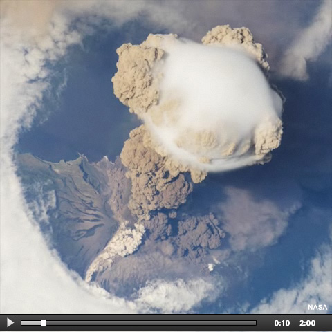
International Space Station view of Sarychev Volcano (Kuril Islands, northeast of Japan) in an early stage of eruption on June 12, 2009. Ash from the multi-day eruption was detected along the main air routes between East Asia and North America, and commercial airline flights were diverted away from the region to minimize the danger of engine failures from ash intake. (NASA)
Classification of Volcanic Eruptions » Plinian Eruptions
The most powerful eruptions are called "Plinian" (or even “ultra-plinian”) and involve the explosive ejection of relatively large amounts of viscous lava. It is named after Pliny the Elder who made observations leading up to the famous AD79 eruption of Mount Vesuvius, Italy. Large Plinian eruptions can send ash and volcanic gas high into the stratosphere from 33,000 ft (10.1 km) to 98,000-131,000 ft (30-40 km) or more. The resulting ash fallout can affect large areas hundreds of miles downwind. Fast-moving deadly pyroclastic flows ("nuées ardentes") are also commonly associated with plinian eruptions.
- A few well known Plinian eruptions of the 20th century include Mount Spurr, Alaska (1992); Mount Pinatubo, Philippines (1991); El Chichón, Mexico (1982); Mount St. Helens, Washington (1980); Agung volcano, Indonesia (1963).
- Some Plinian eruptions inject large quantities of sulfur dioxide into the stratosphere which is converted into aerosols and transported around the globe by high altitude winds. The aerosols block sunlight causing a slight decrease in global surface temperatures. Global cooling was detected with the eruptions of Mount Pinatubo, Philippines (1991), El Chichón, Mexico (1982) and Krakatau (1883) and Agung (1963), Indonesia. The massive eruption of Mount Tambora in Indonesia (1815), is thought to have caused the 1816 "Year without a Summer" in the northeastern U.S., Canada, and western Europe.
- It is important to know the location of Plinian eruptions because of their explosive nature and the amount of ash and gases that are injected high into the atmosphere. Those eruptions occurring in the tropics are more likely to have worldwide impacts as their aerosols will be distributed across both the northern and southern hemispheres.
Classification of Volcanic Eruptions » Questions
Test your knowledge on the classification of volcanic eruptions in the following three questions.
Question 1 of 3
Order (drag-and-drop) the volcanic eruptions below by their relative explosive potential. 1 is Least Explosive, 4 is Most explosive.
Question 2 of 3
Which factors contribute to the explosivity of volcanic eruptions? (Choose all that apply.)
The correct answers are a) and c).
A high-viscosity magma will retain the gases and increase the pressure. This increases the potential for explosive release. The size of lava clots and the height of the volcano do not contribute to the explosiveness of an eruption.
Question 3 of 3
What characteristics of Plinian eruptions make them so dangerous? (Choose all that apply.)
The correct answers are a), b) and c).
Large quantities of ash and gases as well as pyroclastic flows make Plinian eruptions dangerous. Answer d) is incorrect because huge clots of molten lava are associated with Hawaiian and Strombolian type eruptions.
Eruption Frequency and Size
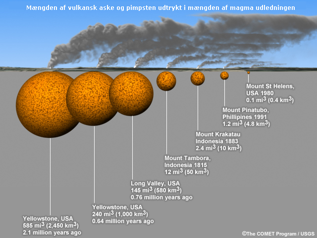
Explosive eruptions are best compared by recalculating the volume of erupted volcanic ash and pumice in terms of the original volume of magma released (shown in this diagram by orange spheres).
Volcanic eruptions come in different sizes and explosiveness. Eruptions can be classified by calculating the amount of erupted volcanic ash and pumice in terms of the volume of magma released. Small eruptions (0.01 km3) occur on the order of once every few months. Very large eruptions (1000+ km3), however, occur about once every 100,000 years. The difference in eruption scales is due to the time it takes to build the necessary magma volume and gas pressure required for a large eruption.
As you can see in the graphic, the Yellowstone eruption 2.1 million years ago released 585 miles3 (2,450 km3) of magma (shown in this diagram by orange spheres), or one-fifth of the volume of Lake Superior. It “was nearly 6,000 times greater than the volume released in the 1980 eruption of Mount St. Helens, Washington, which killed 57 people and caused damage exceeding $1 billion. Even the 1815 Tambora, Indonesia, eruption—the largest on Earth in the past two centuries—was one-fifth the size of the smallest of Yellowstone’s three great prehistoric eruptions” (reference USGS:http://pubs.usgs.gov/fs/2005/3024/ )
Volcanic Hazards
Question
Based on your current understanding, which of the following events are considered volcanic hazards? (Choose all that apply.)
The correct answers are a), b), c), d), e), and g).
Tephra, pyroclastic flows, lahars, lava flows and volcanic gases are all volcanic hazards. Some volcanic eruptions can cause tsunamis too. Fissures do not pose immediate danger unless one were to fall into it.
Different volcanic eruptions can produce different hazards. These are some of the more important hazards:
- Tephra
- Pyroclastic Flows
- Lahars
- Lava Flows
- Volcanic Gases
Each of these hazards are discussed in the following pages.
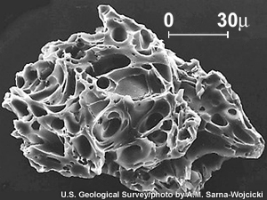
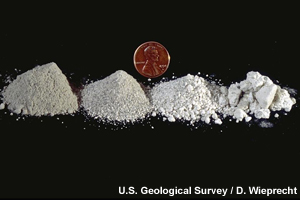
Volcanic Hazards » Tephra
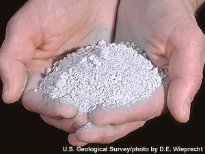 Tephra is a general term for fragments of volcanic rock and lava regardless of size blasted into the air by explosions of hot gases in eruption columns or lava fountains. Tephra includes large dense blocks and bombs, and small light rock debris such as scoria, pumice, and ash. The larger-sized tephra falls close to the volcano, while the wind blows the smaller fragments away from the volcano (see http://volcanoes.usgs.gov/images/pglossary/tephra.php for more information).
Potential effects of volcanic ash fall include:
- Health issues: eye/skin irritation and breathing difficulty
- Daylight turns into darkness and the typical diurnal temperature cycle is reduced (cooler in daytime and warmer at night)
- Roofs may collapse from added weight
- Machinery and vehicles will be abraded
- Deterioration in engine performance and engine failure
- Farmland will be covered
- Roads will be slippery, or blocked
- Power systems may shut down
- Waste-water systems may clog
For more detail on the effects of volcanic ash fall, visit "Societal Impacts" (section 4) of the Impacts module.
Volcanic Hazards » Pyroclastic Flows
A pyroclastic flow is a ground-hugging avalanche of hot ash, pumice, rock fragments, and volcanic gas that rushes down the side of a volcano at speeds in excess of 60 m/hr (100 km/hr). The temperature within a pyroclastic flow may be greater than 900° F (500° C), sufficient to burn and carbonize wood (see http://volcanoes.usgs.gov/images/pglossary/PyroFlow.php for more information).
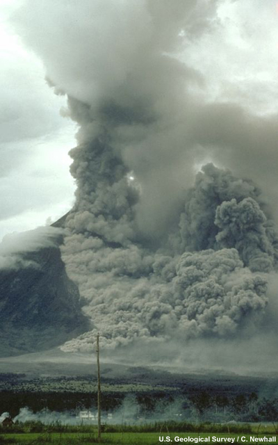
Pyroclastic flow sweeps down the side of Mayon Volcano, Philippines, during an explosive eruption on 15 September 1984. Note the ground-hugging cloud of ash (lower left) that is billowing from the pyroclastic flow and the eruption column rising from the top of the volcano. (U.S. Geological Survey)
A pyroclastic flow can destroy nearly everything in its path. It buries sites with hot rock debris, melts snow and ice to form lahars, and burns forests, crops and buildings (see http://volcanoes.usgs.gov/hazards/pyroclasticflow/index.php for more information).
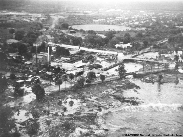
Volcanic Hazards » Lahars
“Lahar” is an Indonesian word for a rapidly flowing mixture of rock debris and water originating on the slopes of a volcano. Lahars are also referred to as volcanic mudflows or debris flows (see http://volcanoes.usgs.gov/images/pglossary/lahar.php for more information). They form in a variety of ways:
- directly through the rapid melting of snow and ice by pyroclastic flows, or ejecting water from a crater lake (Mount St Helens or Eyjafjallajökull)
- directly by the breakout of a lake dammed by volcanic deposits or as consequence of debris avalanches
- Indirectly by intense rainfall during or after an eruption (Mount Pinatubo).
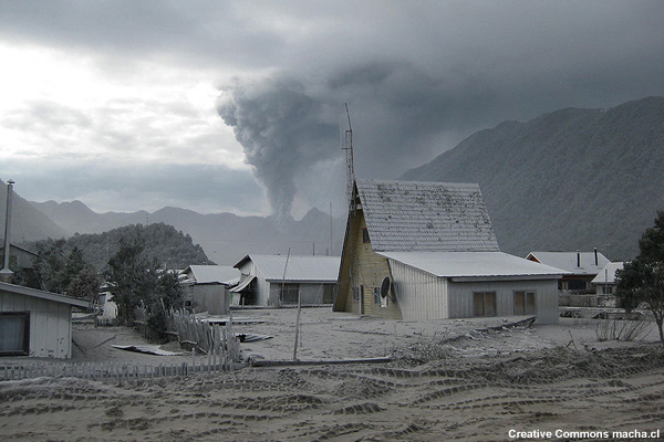
Mount St. Helens erupted often between 1980 and 1986. An explosive eruption on March 19, 1982, sent pumice and ash 9 miles (14 kilometers) into the air, and resulted in a lahar (the dark deposit on the snow) flowing from the crater into the North Fork Toutle River valley. Most of the flow went west down the Toutle River, eventually reaching the Cowlitz River, 50 miles (80 kilometers) downstream. (U.S. Geological Survey)
Lahars can:
- Destroy by direct impact
- Lead to increased deposition of sediment
- Block tributary streams
- Bury valleys and communities with debris
Volcanic Hazards » Lava Flows
Lava flows are masses of molten rock that pour onto the Earth's surface during an effusive eruption. Both moving lava and the resulting solidified deposit are referred to as lava flows. Lava flows threaten everything in their immediate path through intense heat by surrounding or burying everything, by melting snow and ice to form lahars.
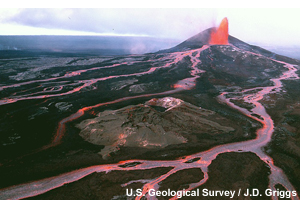
Lava flows spread from a lava fountain on the side of Pu`u `O`o cone, located on the east rift zone of Kilauea Volcano, 1986. (U.S. Geological Survey)
Volcanic Hazards » Volcanic Gases
Magma contains dissolved gases that are released into the atmosphere during eruptions. Gases are also released from magma that either remains below ground or rises toward the surface. Gases may escape continuously into the atmosphere from the soil, volcanic vents, fumaroles, and hydrothermal systems. The most common gases released are:
- Water Vapor (H2O)
- CO2 (carbon dioxide): when trapped in depressions can be lethal to people, and animals
- SO2 (sulfur dioxide): causes air pollution, and affects the Earth’s surface temperature
- H2S (hydrogen sulfide): may cause eye, nose, throat irritation and breathing difficulty, as well as headaches and dizziness
- (HCl) hydrogen chloride: may cause acid rain downwind, and exposure irritates eyes and respiratory tract
See http://volcanoes.usgs.gov/hazards/gas/index.php for more information.
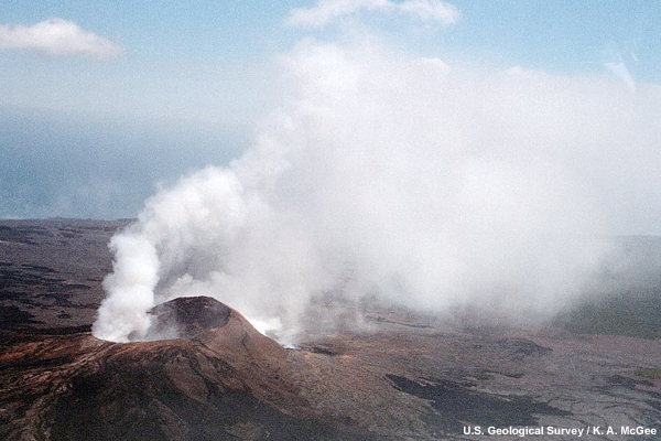
Sulfur dioxide and other volcanic gases rise from the Pu`u `O`o vent on Kilauea Volcano, Hawaii. (U.S. Geological Survey)
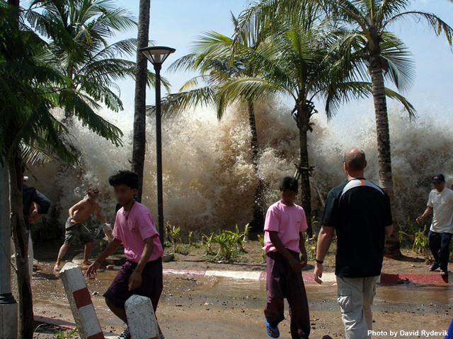
Volcanic Hazards » Tsunami
Tsunami is a Japanese word meaning "harbor wave." A tsunami is a wave or series of waves generated by a sudden disturbance that displaces water. While volcanic eruptions rarely cause tsunamis, eruptions may trigger earthquakes and landslides in coastal regions as well as submarine landslides that could generate tsunamis. For example, the 1883 eruption of Krakatau created a tsunami that killed an estimated 30,000 people. Visit COMET's "Tsunamis" module to learn more about this hazard.
Volcanic Hazards » Questions
Question 1 of 2
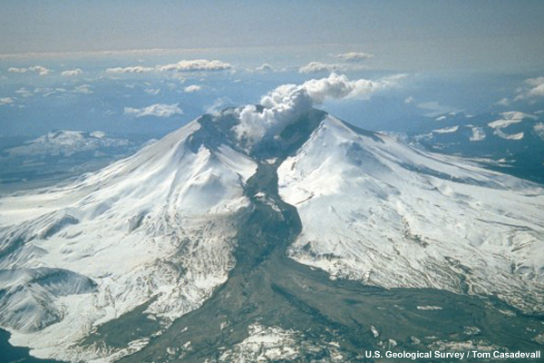
Identify the volcanic features and hazards for each labeled item in the image:
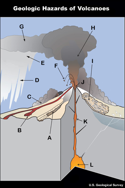
Question 2 of 2
Match the volcanic hazard to the danger it most likely poses.
Summary
This module explored the geologic elements involved in explosive volcanic eruptions. Specifically, the major fault lines and currently active volcanoes are located in the Ring of Fire — defined by a nearly continuous series of oceanic trenches, island arcs, and volcanic mountain ranges and/or boundaries of several plates. Not all volcanoes occur along the Ring of Fire, however, as there are several other areas in the world with active volcanoes, like Iceland and Italy.
Volcanoes come in different shapes and sizes, however, there are several common features. Each volcano has a shallow "plumbing system” that may include a magma chamber that is connected to the surface by a conduit system.
During an eruption, magma rises through more than one crack; some of the magma pushes up the strata layers while other magma moves to the top opening(s) of the volcano. The raised opening that emits magma is called the cone. The crack that reaches to the top of the cone is called the Central Vent. Along with the magma, the volcano emits a cloud of tephra.
Volcanic eruptions form a continuum from small quiet affairs to large explosive catastrophes. Volcanologists have developed many schemes to categorize eruptions. The meteorologist should be familiar with these four eruption types and related ash dispersion patterns:
- Hawaiian — this eruption produces little volcanic ash
- Strombolian — this eruption is short-lived and the ash is not ejected to great heights
- Vulcanian — this eruption produces large quantities of ash that can be dispersed for miles downwind
- Plinian — this eruption produces large quantities of ash that can be ejected high into the stratosphere and circle the globe
Different volcanic eruptions can produce different hazards. These are some of more important hazards and the dangers they pose:
- Tephra — covers broad swaths of land, destroys mechanical equipment, and creates health issues
- Pyroclastic Flows — rapidly burn and destroy everything in their path
- Lahars — destroys structures, covers the land with debris and mud, and may alter rivers and streams
- Lava Flows — slowly burn and destroy everything in their path
- Volcanic Gases — associated with large explosive eruptions; lead to acid rain in the immediate vicinity and possible short-term climatic changes
In future modules, you will learn about the tools used to monitor volcanoes and their eruptions, as well as the models used in forecasting ash dispersion. You will also become familiar with the impacts to aviation, climate, maritime operations and society.
References/Bibliography
Dean, K., Dehn, J. 2011: Monitoring Volcanoes in the North Pacific: Observations from Space," Praxis Publishing Ltd.
USGS: Plate Tectonics in a Nutshell. [Available online from http://volcanoes.usgs.gov/about/edu/dynamicplanet/nutshell.php]
USGS: Volcano Hazards Program Photo Glossary. [Available online from http://volcanoes.usgs.gov/images/pglossary/]
USGS: Volcano Hazards Program Volcanic Gases and Their Effects. [Available online from http://volcanoes.usgs.gov/hazards/gas/index.php]